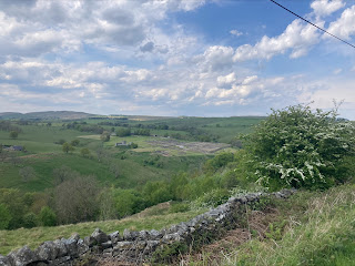
In order to collect sounds for my musique concrète project, I scanned Newcastle's adjacent countryside for somewhere to explore. Quickly I noticed a location I had been eager to visit for a while. The hill south-east of Sunniside, known as Burdon Moor, overlooks the city with panoramic views for miles. I first noticed its arboraceous slopes in the distance from the Quayside's High Level Bridge years ago, and wondered at the sort of views it might offer. After some brief research, it seemed the most of this land was in fact private and not accessible to the public. This irritated me and put me off visiting for months. I thought that such a scenic spot should have the chance to be enjoyed and appreciated.
Looking more closely this time, I searched topographic and OS maps to see if there was an option which didn't involve trespassing. Sure enough, parts of the hilltop itself were free to roam and contained one or two public footpaths. During this research, I learnt about Gateshead Council's "Marking the Ways" project. Founded in 1991, it aimed to fill Gateshead's rural areas with sculptures and artworks to encourage visitors to the area. A handy map showed me the locations of some of the structures, many of which line the sides of the Tanfield Railway, the world's oldest railway in continuous use. Others could be found within Burdon Moor's own lowland heath restoration project, named "Bring Back Burdon Moor." I was intrigued to visit this place too, due to the scarcity of this type of heathland in the North East.
On a sunny day, I caught two buses to get to Sunniside. The elevation of the second bus route took me by surprise. I had had no idea how undulating this part of Gateshead was. Upon reaching Sunniside I began the short mile walk to the top of Burdon Moor. On my way up I found myself beneath some trees full of calling birds. A few minutes of patience later, I managed to capture a recording of them without the interference of passing cars.
Reaching the top of this hill, I was greeted with views that stretched across the horizon. I stood for a few minutes to admire it, trying to spot any landmarks I might recognise. I was amazed to find that I could make out the Simonside Hills way in the distance (which I have previously climbed) and was hit with a feeling of connection to the land and area. The streets around my flat in Heaton are all named after places around these hills, so it was nice to be able to see both in the same view.

I planned to reach three pre-chosen points of interest between Sunniside and Kibblesworth, which I have marked on my route map above. I named these sites Burdon Moor peak, Burdon Moor Heathland Restoration Area, and Angel View (left to right). The first site was livestock grazing land, where I encountered a herd of cows, who even after ten minutes of pestering from me, refused to give me a moo to record. As far as I was concerned, these cows enjoyed stress-free lives in an idyllic location therefore had no reason to complain.
Working my way toward site two, I unbelievably found a McDonald's sauce packet and a vape nestled along the footpath and road. It bewildered me that someone would litter on such solemn-trodden and innocent land. I picked these items up and entered the next field, where a pair of birds refused to cease circling me as I travelled. I took this opportunity to get a nice stereo recording of the bird song as the whipped about me in 360 degrees.
The restoration area was fascinating to learn about but offered little in the way of sounds, other than the trickling water of a small confluence of streams. I found two of the sculptures from the "Marking the Ways" project. Both were formed of large stones with inscriptions. One had small butterflies on it. Leaving the area on the Bowes Railway path, I passed by the only two people I would see on my excursion, a pair of cyclists.
My final point of interest intrigued me. I could see that it was publicly accessible, but looking at Strava's heatmap feature, very few people ever went there. When I arrived, I found the path very overgrown and challenging to pass through. I succumbed to a few nettles and thorns before emerging on the hillside, which offered a great expansive view of the Gateshead and Sunderland areas. Central in the frame however, was a huge plume of black smoke coming from an industrial park. A quick google later revealed that I was witnessing a large-scale fire in Birtley which delayed trains on the East Coast Main Line. Here the birds were really noisy so I recorded some more.

My escape from this location, however, proved more difficult. I managed to find myself on private farmland despite having accessed it via a public footpath. Without much time until the hourly bus from Kibblesworth, I executed some slightly dodgy moves to beeline towards the road. I met some sheep on the way who thankfully were able to produce me some bleating for my project. Thanks sheep! After almost losing an eye weaving through dense saplings and tearing my trousers on a barbed wire fence, I was safely on a road and was able to jog leisurely to my destination.


Comments
Post a Comment